
🚴♂️ Trail Overview • Length: 29.2 miles (Polk City to Mabel) • Surface: Paved, 12-foot-wide asphalt • Terrain: Flat, straight, minimal elevation changes • Activities: Biking, walking, inline skating, horseback […]
🚴♂️ Trail Overview
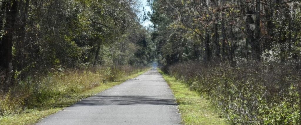
• Length: 29.2 miles (Polk City to Mabel)
• Surface: Paved, 12-foot-wide asphalt
• Terrain: Flat, straight, minimal elevation changes
• Activities: Biking, walking, inline skating, horseback riding (parallel equestrian trail)
The trail closely follows the old Seaboard Air Line Railroad corridor and is now part of Florida’s Statewide Greenways & Trails System and a National Recreation Trail.
⸻
🗺️ Trail Map and Access Points
The Van Fleet Trail has four primary trailheads, approximately 9–10 miles apart:
Trailhead | Location | Parking | Restrooms | Picnic Area |
Polk City | 7683 Berkley Rd, Polk City, FL | ✅ | ✅ | ✅ |
Green Pond | Green Pond Rd, Polk City area | ✅ | ✅ | ✅ |
Bay Lake | Bay Lake Rd (CR 565), Mascotte | ✅ | ✅ | ✅ |
Mabel | CR 772 just south of SR 50 | ✅ | ✅ | ✅ |
🚗 Directions to Trailheads:
• Polk City: From I-4, exit 38 onto SR 33 north for ~5.8 miles. Trailhead is just beyond CR 665.
• Green Pond: From SR 33, turn west onto Green Pond Rd and continue ~1 mile to parking.
• Bay Lake: From SR 33, turn east onto Bay Lake Rd (CR 565) to reach the trailhead.
• Mabel: Access from CR 772, just south of SR 50, near the Mabel post office.
⸻
🎖️ The Legacy of General James A. Van Fleet
The trail honors General James A. Van Fleet, a highly decorated U.S. Army officer who served in World War I, World War II, and the Korean War.
• Born: March 19, 1892, in New Jersey, but raised in Bartow, Florida
• Military Highlights:
• Commanded troops at Utah Beach on D-Day during WWII
• Led the U.S. Eighth Army in the Korean War
• Received the Distinguished Service Cross, Silver Star, Bronze Star, and Purple Heart
• Van Fleet was praised by President Truman as “America’s greatest general” and lived to 100 years old, passing away in 1992 at his ranch near Polk City.
The trail is a fitting tribute to his leadership and his strong connection to the local area.
⸻
🌿 Wildlife and Weather Tips
🐢 Wildlife to Expect
• Alligators: Frequently seen along water bodies and occasionally sunning on the trail
• Turtles and Snakes: Common on the trail, especially in warm weather
• Birds: Herons, egrets, hawks, and wild turkeys
• Mammals: Deer, raccoons, armadillos, and sometimes bobcats
🛑 Wildlife Safety:
Always maintain a respectful distance, particularly from alligators. Do not feed or approach animals. Be aware of turtles or snakes on the trail.
⸻
🌤️ Weather Considerations
• Best Seasons: Fall, winter, and spring (October–April)
• Summer Risks: High heat, humidity, and afternoon thunderstorms (May–September)
• Trail Exposure: Limited shade—sunscreen, hats, and plenty of water are essential
• Mosquitoes: Bring insect repellent, especially near the Green Swamp
⸻
🔶 Additional Safety Notes:
• Hunting is allowed in adjacent wildlife areas. Wear orange during hunting season (typically fall and winter months).
• Cell service is limited in remote areas—download maps beforehand and let someone know your route.
⸻
🚐 Shuttle Options and Return Planning
1. Bike Shuttle Service: Bubba’s Pampered Pedalers
• Phone: (206) 250-3395
• Email: pamperedpedalers@gmail.com
• Bubba’s offers morning shuttles to the Mabel trailhead, allowing cyclists to ride one way back to Polk City. Advanced reservations are recommended.
2. DIY Self-Shuttle
• The most common option: use two vehicles. Park one at your finish point (Polk City or Mabel) and drive the other to your starting point.
3. Rental Car Option
• Some cyclists arrange a one-way ride using rental cars, particularly if combining with the nearby Auburndale TECO Trail.
⸻
📌 Final Recommendations
• Start early: Beat the heat and wildlife activity.
• Plan your route: Decide whether to ride round-trip or arrange a shuttle/vehicle drop.
• Stay hydrated: Bring more water than you think you’ll need.
• Be self-sufficient: Carry basic bike tools, a first aid kit, and emergency contacts.
⸻
🗺 Printable Guide (PDF with Cue Sheets & Map)
Download the detailed PDF guide including maps, cue sheets, trail descriptions, and trailhead info:
• General James A. Van Fleet Map & Cue Sheet (Bike Florida PDF) – includes mile-by-mile directions and trail map .
⸻
🚲 GPX & FIT Route Files
Ideal for loading into bike computers or GPS apps:
• GPX Track – official route file for the full 29.2-mile trail .
• FIT Course File – supported by Garmin and other fitness devices .
⸻
📥 How to Get the Files
1. Visit the Bike Florida trail page (search result indicates availability).
2. Click to download:
• Map and Cue Sheet (PDF)
• GPX Track (.gpx)
• FIT Course (.fit)
(Look under “Maps and Other Files”) .
3. Import the GPX or FIT file into your device or app (Garmin, Strava, Komoot, etc.).
4. Print the PDF guide or save it as a PDF on your phone/tablet for easy reference.
⸻
Here’s your complete printable guide and GPX route files for the Van Fleet Trail:
✅ Quick Start Tips
• Load GPX before heading out, since reception is unreliable along the route.
• Use the cue sheets for quick reference to trailheads and mileage markers.
• Bring a paper backup—the booklet includes the full map and descriptions.
• The file set includes full route info with cue points at each trailhead (Polk City, Green Pond, Bay Lake, Mabel).
Useful Resources
• Florida State Parks – Van Fleet Trail
• Florida Rambler – Van Fleet Trail Guide